30 January 2012

Folsom Frolic

#140

Saturday, January 28th

My sweetheart asked ME to go on a bike ride. Usually it is the other way around.

I have that new little 'spy' camera to play with, so I stuck it on my hat and away we went.


16 January 2012

Ally Oop(s)

#139

Monday, January 16th
Folsom. About 6 miles? I don't know. I wasn't in charge today.

I met Al for a short meander in Folsom. It was cold but sunny. We were both imitating the Michelin man a little bit. I even wore my old Terry cool-weather tights. AND I had a wool Buff around my head for most of the ride. And two layers of merino wool AND a windbreaker. And gloves.
You get the picture.

We discussed Life the Universe and Everything and came to few useful conclusions. Topped off with a nice Subway lunch. I was good and left off the cheese and mayo in favor of nice avocado.

Anyway.

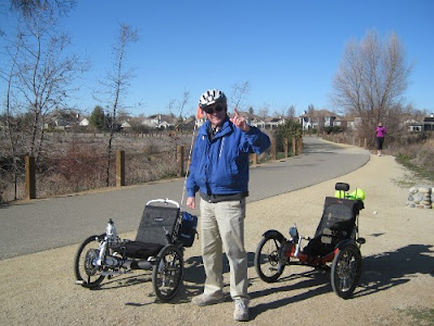
Today was the big day when Al finally joined the club


 No, he does not normally store his trike in the landscaping, but he got a little crazy with the two wheel thing and found a nice soft landing spot. I was a little slow to get the shot of Al reclining in the shrubs along with his trike. Later on in the ride I saw him successfully demonstrate 2 wheel riding. Pretty cool. Not something I am ready to try.

I've been experimenting a little (and tentatively) with brake-steering, easily done - sometimes too easily - with independent left-right brakes. I think I could grow to like it. It certainly whips one around the corners smartly.

A Ham.

Another thing that Al does is build interesting things for his ride. Maybe his cousin is Inspector Gadget.
I failed to guess what this was (the white bar under the boom) but Al took pity on me and told me.


It keeps his trousers out of the chain when he loads and unloads his bike from the car. Pretty slick. I suggested he cap the other end and store a flywhisk or something in it. Now I'm thinking a back-scratcher might be better.
Oh I know, I know!
M&Ms. The peanut kind. Put a little trap door on the bottom and dispense as you ride. As long as it didn't get too hot, it would be great.


Some other ride some other day upcoming, I'm sure. Maybe it will rain and I can try out my heretofore unused rain gear.

15 January 2012

Bunch of Fun

#138

Sunday, January 15th

I cruised around the lake (Lake Natoma) today with a pack of 18 cheerful casual riders. It was a little cold, and maybe a bit windy (but nothing like last weekend). We rolled on anyway, having a good time. This ride organizing is getting a little easier as I do it every month.


I successfully ran my little bitty 808 HD camera, attached to the visor of the cap I wear under my bike helmet. The videos are OK, I need to do a lot of editing since my bicycle technique apparently involves a lot of head-bobbing. I might try mounting the camera on my right front fender next time. It is light enough it sticks on with a bit of velcro. The video quality is not enough to clip stills out of, but then that's not why I bought the camera!

I did have one tiny moment of glory today. We were coming up from Negro Bar, on my alternate route to the Folsom-Auburn Rd bridge, when we passed two confused looking cyclists. They were looking for the bridge, so for a little while my comet-trail of fellow riders was increased by two. I was glad to help them out.


I'll head out tomorrow on a short excursion with "Parking lot Al" and our trikes. It will be good to see him again.

I PROMISE pictures tomorrow! Really.

Taken by one of the Eighteen

13 January 2012

The problem is not the camera

#137

Short jaunt in Folsom
Friday, January 13th

I got a hold of an 808 camera (a little bitty primitive 30 frames-per-second HD video camera built in a automotive remote fob).

I tried to take some video today.

I, as usual, was terminally camera-confused and spent my entire ride talking to a turned-off camera. I'll try again on Sunday's ride.

So no pictures, no report, and no joy.

CU later!

09 January 2012

updownupdownupdownupdown

#136

Monday, January 9th
Folsom, CA

I said I'd go out and practice on hills.

So I did.

I devised a 12 mile route that has just the right amount of climbing and variety for my current state of legs/wind, went out, and took it for a spin.

It was a beautiful winter day. I wore shorts and a summer-weight top. I was comfortable in the 60 degree weather. I got some funny looks in the grocery store after my ride, but I figure most middle-aged women don't wander around in a bicycling skirt and screaming blue shirt in the middle of winter, even in California.

Fashion aside, here's today's elevation profile.


I took the Oak Parkway bike trail west from Green Valley (the little hills trending downward until about mile 3).


Then I scooted along East Natoma St., waving to some of the Sacramento Wheelmen that were out today heading in the opposite direction. (That took me halfway up the first big rise on the elevation profile)

I slogged my way up the short side of Folsom Crossing, admiring flowers, the lake and construction along the way.


I gleefully sailed down the other side (to about mile 5.7).

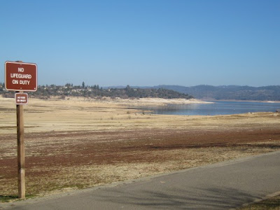
Then I dragged myself and my trike up to Beals Point (just before mile 8), where I spent some time gazing at the not-lake

How could I resist this picture?

and chatting with a retired Army guy (the ball cap gave it away) about life, the lake, exercise. No idea what his name is. Good conversation anyway.

Then I bombed down Beals (I even pedaled a little bit down the 2 miles of downhill) and crept up the long side of Folsom crossing (for another scant mile) and then down the last downhill back to my start.

My max speed was about 30mph and my average was about 9mph.

I don't know that there is a good way to get accurate elevation information for a ride. The Tracks program (an Android app) I used today uses gps satellite information to determine elevations. That's how a GPS unit like a Garmin would also. Would it do a better job? I don't know.
The ridewithgps site (where I record my trips when I bother to do so) uses whatever system Google Maps uses. I have been told that ridewithgps overstates the elevation by 20-30%.

The Tracks program yielded an elevation gain/loss of +622 / -619 feet. RWGPS wanted to change it to +1706 / -1705 feet.

Two and three quarters times different?
You've got to be kidding me!
Should I split the difference? Flip a coin? Give up and get some coffee?

uh

The coffee won.

See ya later.

(caffeinated update: 600-some that Tracks gave me is the net elevation gain/loss. The other, larger number, is a sum of ALL the updownupdownupdown I did today)

UPDATE: I reverted to my uploaded route information created by Google Tracks on my phone. I decided I liked Tracks' inaccurate elevation information better than RWGPS'. So I will state that my elevation gain/loss was around 1600 feet. Respectable.

Today's ride map. If you go over to the site (click here), you can playback my ride and do other amusing and time-wasting things.

07 January 2012

But, I Digress

#135

Saturday, January 7th

30 miles on the American River Trail

The usual ride (William Pond and back in one direction or another) with the usual suspects (Sacramento Recumbent Riders) is happening next weekend. I'll be hiking then, so I decided to start in Folsom and go to Wm Pond and back again.

It was WINDY. Like, gusts to 40mph. After about 20 miles, my brain felt like this.


I saw lots of people out also battling the wind, and birds taking advantage of the free ride south on the strong north wind.


Fishermen all along the river. The river's pretty low now since it has hardly rained at all this winter.


My flag, for a wonder, stayed put. But the flapping was deafening at times.


The ever popular waterfountain at Wm Pond was the stealth attack fountain today. If you stood downwind of it when someone was filling up, you'd likely get splashed.

I took several breaks, standing in the lee of various structures to give myself a leg break but most importantly, a wind break.

I only got stuff in my eye once. I got whapped in the face by a leaf and there were also lots of twigs to run over on the trail.

I was tired enough by the time I was coming home I took a nifty detour avoiding the steep hill just upstream of Sunrise boat launch. Thanks, Al, for showing me that. I also detoured around the Hazel crossing both times, using the bike lanes along Gold Country Blvd.


Although I wondered about my decision to do the whole 30 miles today, I'm glad I did.

01 January 2012

Head like an ice cube

Sunday, January 1st

Happy New Year

#134

What is the windchill at 44 degrees and 40mph? Hm. Let's look that up.
About 30 degrees. Which would be below freezing.

Which would explain why, while bombing down hill at 39.2 mph (my personal best so far) on a chilly calm morning, my whole skull felt like your hand does when you stick it in a tub of icewater.

What. You don't go around randomly sticking your hands in icewater? Why not?!
I would also like to note that it is difficult to keep one's eyes open at that speed/temp combo.

Today was the Hammerin' Wheels' 2nd annual Beatty Hill Climbing Smackdown Challenge something-or-other. Hill repeats for 2 hours.

I did not do that hill. Not even once. I volunteered again, this year helping with registration and with the refreshment stop at the bottom of the hill. We had, as far as I know, a little over 50 participants. Last year (cold and rainy and windy) had 20-some.

I handed out bananas, oranges, gatoraid and water, and collected jerseys, arm and leg warmers from the rapidly warming participants.

The volunteer organizers of this event made nifty laminated bibs for early registrants. I got one, even though I was just volunteering.


This time I rode the 8 or so miles from my house, hung around volunteering, and then turned around and rode back.

I had another 'standing flat' (I park my bike somewhere and return later to find one tire flat). I'm just glad it did not go flat on a downhill. I have become quite nonchalant about flats: I can now hold a conversation while changing one.

I wore a lightweight short sleeved merino wool Ibex top and a midweight long sleeved Ibex top and some Danskin exercise tights. I had originally had my merino wool Buff deployed in earband mode, but after the first ice-cube head incident, I switched to balaclava mode, pulling it off my face when not going downhill. My head was still cold, but not icy.

I also had wool gloves on the whole ride.

After I got up the first hill (right out of my driveway as I'm sure you've heard me whining about before) I took off the longsleeved wool shirt and put on my bright windbreaker. I was a little cold downhill, but I really did not want to get too sweaty on the ride in and then stand around getting hypothermia or something dire like that while volunteering.
On the way back I had just my Danskin tights and the short sleeved top and I sweated plenty.

All told, it took me 2 hours and 20 minutes to go the 17 miles round trip. I averaged 10 mph on the way out and my overall average was 7.1. Just under 2000 feet of climbing today.

This year my goal is to get better at climbing hills. Which means I must push myself a little bit.

The red is elevation and the wiggly lines are the grade. Lots of down followed by lots of up.