Monday, January 9th
Folsom, CA
I said I'd go out and practice on hills.
So I did.
I devised a 12 mile route that has just the right amount of climbing and variety for my current state of legs/wind, went out, and took it for a spin.
It was a beautiful winter day. I wore shorts and a summer-weight top. I was comfortable in the 60 degree weather. I got some funny looks in the grocery store after my ride, but I figure most middle-aged women don't wander around in a bicycling skirt and screaming blue shirt in the middle of winter, even in California.
Fashion aside, here's today's elevation profile.
I took the Oak Parkway bike trail west from Green Valley (the little hills trending downward until about mile 3).
Then I scooted along East Natoma St., waving to some of the Sacramento Wheelmen that were out today heading in the opposite direction. (That took me halfway up the first big rise on the elevation profile)
I slogged my way up the short side of Folsom Crossing, admiring flowers, the lake and construction along the way.
I gleefully sailed down the other side (to about mile 5.7).
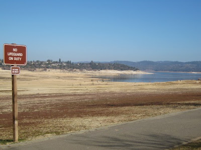
Then I dragged myself and my trike up to Beals Point (just before mile 8), where I spent some time gazing at the not-lake
 |
| How could I resist this picture? |
and chatting with a retired Army guy (the ball cap gave it away) about life, the lake, exercise. No idea what his name is. Good conversation anyway.
Then I bombed down Beals (I even pedaled a little bit down the 2 miles of downhill) and crept up the long side of Folsom crossing (for another scant mile) and then down the last downhill back to my start.
My max speed was about 30mph and my average was about 9mph.
I don't know that there is a good way to get accurate elevation information for a ride. The Tracks program (an Android app) I used today uses gps satellite information to determine elevations. That's how a GPS unit like a Garmin would also. Would it do a better job? I don't know.
The ridewithgps site (where I record my trips when I bother to do so) uses whatever system Google Maps uses. I have been told that ridewithgps overstates the elevation by 20-30%.
UPDATE: I reverted to my uploaded route information created by Google Tracks on my phone. I decided I liked Tracks' inaccurate elevation information better than RWGPS'. So I will state that my elevation gain/loss was around 1600 feet. Respectable.
Today's ride map. If you go over to the site (click here), you can playback my ride and do other amusing and time-wasting things.


No comments:
Post a Comment